Trimble UAS Software
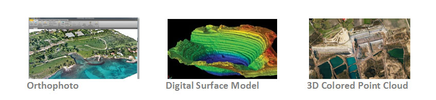
Trimble offers UAS image data processing software for your needs with modern computer-vision algorithms combined with proven state-of-the-art photogrammetric techniques to produce deliverables with the highest accuracy, with minimal manual interaction.
The Trimble Business Center Aerial Photogrammetry Module was developed for Professional Land Surveyors working with small UAS from Trimble, and Inpho UASMaster was developed for Professional Photogrammetrists working with data from small UAS (of any type).
| TBC Aerial Photogrammetry Module | UASMaster – Inpho |
| ✓ High Resolution Orthomosaic | ✓ High Resolution Orthomosaic |
| ✓ True Color Point Cloud (DTM & DSM) | ✓ True Color Point Cloud (DTM & DSM) |
| ✓ Relative and Adjustment with Ground Control | ✓ Relative and Adjustment with Ground Control |
| ✓ Coordinate System Management | ✓ Coordinate System Management |
| ✓ CAD & Drafting Tools | ✓ CAD & Drafting Tools |
| GNSS Baseline and Total Station Processing | Support for non-Trimble UAV platforms |
| Survey Network Adjustment and Site Calibration | Support for Multi-Rotor Platforms |
| Volume Calculations | Integration with Inpho , Interactive Editing Workflow |
| Advanced CAD and COGO Tools | Manual Measurement of Tie Points |
| For Professional Land Surveyors working with Trimble UAS | For Professional Photogrammetrists working with UAS of any type |